ISSN: 2977-814X
ISSUE DOI: https://doi.org/10.51596/sijocp.v2i1 Volume 2 Issue 1
Ece Sila Bora1, MSc, Queen’s University of Belfast, United Kingdom
![]()
Received March 25, 2022
Accepted May 15, 2022
Published Online July 25, 2022
https://doi.org/10.51596/sijocp.v2i1.55
![]()
Abstract
This study aims to show how the act of mapping could contribute to our existing knowledge about cities. Mapping has long been used as a tool for understanding physical space. Lately, scholars also used it as a method of examining the places on the screen. Belfast, a city in which a profound sectarian dispute exists, has become the setting of many conflict-themed films. This research claims that mapping film locations in Belfast could provide an archive to examine the transformation of urban texture and architecture. Analysis of the city image in two films, The Mighty Celt (2005) and Belfast Girls (2006), could help to reveal the physical change of the city from different perspectives. In the first one, Belfast is a hostile background experienced from the eyes of a young boy, while the second one documents the life of two girls from diverse backgrounds, a Protestant and a Catholic. Both films are set in Northern Ireland during the post- Trouble period, during which the division between the two groups persisted. These films make a contemporary portrait of Belfast as a divided city where armed conflicts have ended, but physical segregation remains. By analysing these two narratives, the study will try to interpret the complex urban conditions in Belfast at the beginning of the century.
Keywords: mapping, film location, divided city, Belfast, cartographic cinema
![]()
Introduction
Since the city symphonies1 of the early twentieth century, cinema has served as a tool for portraying the urban space. Early films attempted to reflect the ov erwhelming pace of modernity by representing the new and dynamic urban life and daily experiences. Later, films elaborated on more specific urban problems such as race, social class, urban alienation, and dehumanisation (Weiner, 1970). Thus, they become an essential medium to understand the complexity, diversity, and social dynamism of the city. In recent years, film and geography have become more intertwined as two spatial fields, setting new perspectives for exploring the urban environment. The expanding discourse of film, space, and place has a variety of discussions around some cartographic themes. Among them, mapping, which has long been used as a tool for understanding physical space, has started to be used as a method of analysing places on the screen. Mapping film locations, particularly, provides new insights into space since films set in the city constitute a substantial archive of the urban landscape.
This study aims to analyse the representation of the built environment in post-conflict Belfast films by mapping two films’ locations. Belfast, one of two Irish capitals in a sectarian dispute, has frequently been used as a setting for conflict-themed films. The ongoing co ntention between Catholic nationalists and Protestant loyalists has significantly affected the social norms and
the built environment, as well as the cinematic representations. Movies set in the culmination period of the conflict portray how the city centre shrank due to the tension and violence in that period. On the other hand, post-conflict-themed films depict a recuperating city, though under the shadow of the past. Two Belfast films, The Mighty Celt (2005) and Belfast Girls (2006), set in the post-conflict city, provide an extensive recording of the changing urban conditions in that period. The former characterises Belfast as a hostile background experienced from the eyes of a young Catholic boy. The latter documents the life of a Protestant and a Catholic girl. They draw a contemporary portrait of the ‘divided’ city in the post-Troubles period.
Accordingly, this paper begins with brief information on the historical background of the conflict and its enforcement on the built environment. It continues with a general overview of the existing studies at the intersection of space, film, and mapping. Then, it comparatively analyses the visual and locational data extracted from case studies.
Belfast as a Divided City
Throughout history, Northern Ireland has witnessed an everlasting conflict between republican Catholics and unionist Protestants. Tension in the country rose steadily in the 20th century with the migration from rural to urban and the rapid densification of the city centre. During this time, competition for accommodation and employment exacerbated feelings of sectarianism in Belfast (Calame and Charlesworth, 2011). Throughout the 1960s, the civil rights movement gained strength among the Catholic new generation. It eventually led to the civil rights marches at the end of the decade, causing a backlash and subsequent riots from the opposing Protestant unionist community. Encountering in the public sphere initiated a long period of civil unrest, paramilitary activity and the intervention of the British Army, which is known as ‘The Troubles’ and this period brought the outbreak of street violence, widespread bombing attacks on civilian, public and military targets, massive migration and separation of Protestant and Catholic communities. During the Troubles, more than 3500 people were killed, and thousands of people in the Greater Belfast area were forced out of their homes (Maguire, 2009).
The Troubles had crucial consequences for the urban environment. The city centre became secluded due to the tension and violence. There was strict military control over the public space. The wired barricades put in several streets as a temporary measurement has become permanent in time. All kinds of barriers have gradually spread into Belfast by increasing in number and size (Belfast Interface Project, 2017). The passing of emergency provisions in 1969 allowed militarised architecture composed of watchtowers, checkpoints, fortifications, barricades and ‘peace walls’ (Coyles, 2017). In 1998, political negotiations and paramilitary ceasefires resulted in the Good Friday Agreement, establishing a power-sharing administration between unionists and Irish nationalists. In the years after, there has been a sustained period of relative peace. The armed conflict has ended, but physical segregation has remained. 2011 census showed that about 76% of the population of Belfast still lived in segregated communities (Shuttleworth and Lloyd, 2013). Despite the policymakers’ efforts to reconstruct a non-controversial image of Belfast, the city is still divided in most parts.
Mapping the Cinematic City
The interaction between city, film and cartography has been the subject of an expanding corpus in recent years. The act of mapping has particularly become prominent since the ‘spatial shift’ in humanities in the 1990s. A vast number of scholars from diverse academic backgrounds, such as geography, urban studies, architecture, history, literature, film, and cultural studies, are contributing to the subject. Much of the scholarship is interested in cinema due to its ability to provide new insights into our understanding of urban modernity (Hallam and Roberts, 2014). Les Roberts claims that ‘thinking spatially’ has initiated a growing body of research on film that could be gathered under the title of ‘cinematic cartography’. He outlines some theoretical and methodological ways that film and cartography have started to intersect, such as mapping of film production and reception, film-related tourism, maps embedded in films, and cognitive and emotional mapping (2012). These studies provide a new lens into the employment of cartographic methods while discussing films. However, they mostly take a geographic or cinematic approach,
which exemplifies the distinct usages of mapping. On the other hand, an architectural approach could introduce mapping as a creative method to see spatial relations.
Relatively, there are few studies using mapping techniques to analyse cinematic cities with an architectural approach. One of them is the Mapping the City in Film project (2008-2010) conducted at Liverpool University. Interdisciplinary research brings together scholars from the fields of architecture, media, film, and social studies. It aims to analyse Liverpool’s changing cityscape through its representations in films. In the project, the catalogued films are presented as an extensive spatial database depicting the spatial changes and dislocations in the city fabric. Overall, researchers open new discussions on mapping’s potential to offer new tools for urban historians and the extent to which film could function as a form of spatial critique [1].
Researchers from the University of Cambridge conducted a similar project in London entitled Cinematic Geographies of Battersea (2012-2013). In the study, they combine rational approaches to analyse the physical space and qualitative methods to cover the intangible qualities of the city. They delve into different cinematic layers accumulated on the urban fabric to demonstrate the transformation of the urban environment [2]. In the process of what they call cinematic urban archaeology, they document Battersea films categorised according to the setting and the shooting location. Their main goal is to understand how real space relates to its cinematic representation and how urban historians could benefit from this data to produce new spatial knowledge. They assert that fiction films are useful documents for historians because they feature landmarks and iconic buildings that have been partially or entirely destroyed (Penz, Reid and Thomas, 2017).
Another prominent attempt at cinematographic maps is The World Film Locations series. So far, the collection consists of 41 books looking at different cinematic cities worldwide. Each book analyses a city by featuring film location maps, film stills as well as brief articles. Authors attempt to explore the ways cinema shapes our perception of the city, the city’s role in films and the film’s function in engaging people with different cultures. The maps in the project give an opportunity to see the various conceptualisations of the city over the years [3].
In brief, the existing research on cinematic cartography has underlined various uses of mapping to analyse cinematic cities. They also focus on the change in spatial uses and physical elements to investigate the city’s ever-changing dynamics. The case studies below intend to highlight the visible and intangible sectarian conditions in post-conflict Belfast by mapping its cinematic locations.
Case Studies
This part of the paper presents a description of the mapping methodology and its application to analyse the two post troubles Belfast films, The Mighty Celt (2005) and Belfast Girls (2006). The first film, The Mighty Celt, is centred around a 14-year-old Catholic boy, Donal. The film, set against the backdrop of the contemporary political situation in Northern Ireland, represents the nascent tensions between different segments of the Catholic community [4]. Through the eyes of Donal, ongoing divisions in the city are told. The second film, Belfast Girls, is a documentary about two teenage girls from opposing communities: Catholic Mairy McIlkenny and Protestant Christine Savage. It documents the effects of the conflict on daily life as their communities are ideologically, physically and physiologically divided. This research examines the visual data collected from these two films. Firstly, it creates an extensive dataset including the major shooting locations in Belfast and processes them by employing Geographical Information Systems. Accordingly, it assigns different colours to each film. The green dots represent locations in The Mighty Celt, while the pink ones correspond to Belfast Girls’.
In both cases, the city is a “conditioning factor adding to the film’s impact” by contributing to the narrative (Caldwell, 2008, p. 123). Beyond being a backdrop or a setting, it becomes a protagonist. The decision to shoot on location contributes to the authenticity. Both films make a realistic portrayal of the recently established peace period in Belfast. The Mighty Celt mostly takes place in Catholic parts of the city (i.e., Short Strand area in the east, Ballymurphy and Andersonstown in the west), whereas Belfast Girls takes place in different Catholic and Protestant neighbourhoods (i.e., Short Strand and Ballymacarret in the east, Ardoyne in the north-west, Shankill and Falls in
the west) (Figure 1).
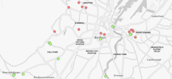
Figure 1. The dissemination of film locations in Belfast (produced by the author).
The east part of Belfast is a prominent filming location for both films. Although this part of the city is predominantly Loyalist Protestant, it shelters a small Republican Catholic community in a particular area, the Short Strand neighbourhood. East Belfast, the former centre of Northern Ireland’s shipbuilding industry, experienced an economic collapse in the post-industrial period. The government-funded redevelopment projects resulted in the transformation of continuous street patterns into discontinuous, segregated residential neighbourhoods due to security concerns (Coyles, Hamber and Grant, 2021). There are certain areas only accessible by pedestrians. Sectarian and political murals on walls are landmarks of each community. In Belfast Girls, we see Christine, the Protestant girl, wandering along one of these walls in Newtownards Road. Although she can go across the Catholic neighbourhood standing beyond the road, she deliberately chooses to walk from the Protestant side until she reaches her house. Drawing her walking route illustrates not only the physical but also the physiological borders of the city (Figure 2).

Figure 2. Mapping of character’s movement in Belfast Girls (produced by the author).
Another landmark here is the barrier in Madrid Street, which has substantially changed throughout the years. The continuous street in the Troubles period was closed by a physical
barrier after the violent events in 2002 (Belfast Interface Project, 2017). The credit sequence of The Mighty Celt depicts two sides of this wall with an aerial shot. The camera starts primarily filming the Protestant neighbourhood, showing children throwing stones over the wall. Catholic children, on the other side, wear helmets. A key point to notice here is the mural depicting the continuation of the street. The perspective drawing on the wall attempts to remove the physical border discretely. As seen here, borders in the city employ both physical and psychological mechanisms.
On the other hand, these barriers are not fixed architectural elements. They change over time, similar to people living around them. To illustrate, in Belfast Girls, one could note the change of the same wall between two scenes. The mural depicting the continuation of the street becomes more detailed and colourful in the latter one (Figure 3). Even though the physical existence of the border remains, the perception and the experience of the space change with users’ intervention.
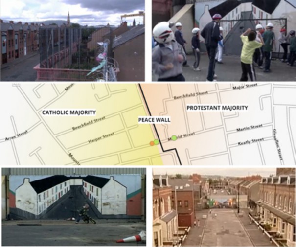
Figure 3. Mapping of film scenes in Madrid Street (produced by the author).
A further major setting for both films is the city centre. The physical and immaterial borders dissolve slightly here due to the deliberate attempts to recreate a modern image of the city in the post-industrial era. In the 1980s and 1990s, new developments in Belfast reflected the city’s economic revival as the stagnation caused by political instability gave way to a period of urban regeneration (Larmour, 2006). Urban regeneration is mostly implemented in the central area. Accordingly, the cinematic representations illustrate a refurbished Belfast with commercial and entertainment facilities. They screen divisive elements less, contrary to the Troubles-themed films, which associate the city centre with violence and decay. In The Mighty Celt, the Lagan riverside is portrayed as a recreational area where characters enjoy the landscape. In Belfast Girls, Donegal Place is presented as a major commercial centre that is free from the division that still exists in some residential areas (Figure 4). Here, one of the protagonists, Mairy, distracts
herself from the burdens of living in a segregated community.

Figure 4. Belfast city centre (The Mighty Celt, 2005), (Belfast Girls, 2006).
A different scene in Belfast Girls offers a glimpse into the Orange Marches, a series of Protestant parades held on 12 July every year. The sequence starts in central Belfast in Donegall Square, depicting the parade marching in front of the City Hall. Here, there is no conflict or protests during the parade. It is portrayed as a cultural celebration of a particular community, which everyone enjoys and participates in. However, the representation of the same event transforms when the parade reaches Crumlin Road in the following scenes. It is because this road is located at the junction of the two opposing communities, a Catholic majority in the upper part and a Protestant majority in the southern part. Here, the Catholic community reacts to the parade. Security forces set up barriers to prevent potential conflicts. Contrary to the scene set in the city centre, the same event gives room to tension and reaction in Crumlin Road. These distinct representations highlight the different physical and physiological fractures in the city (Figure 5).

Figure 5. Mapping of the parade’s route in Belfast Girls (produced by the author).
The west part of Belfast is also frequently filmed. Domestic scenes in the films take place in some of the Catholic-majority urban fringes, such as Andersonstown and Lenadoon. Donal in The Mighty Celt grows up in one of these Catholic areas. Likewise, Mairy and Christine prefer to live in their secure Catholic and Protestant neighbourhoods in Belfast Girls. The interaction with others is limited in these communities. However, this condition is challenged by some encounters in daily life. For example, Christine finds a Catholic boyfriend, whereas Mairy’s roommate finds a Protestant one. Thus, they begin to interact with the opposing community. It is interesting to note
that people prefer to adhere to their familiar territories in the post-conflict era. This shows that Belfast has remained a divided city in people’s perception even after the Troubles. However, the peace period provides room for social encounters and dialogue.
Analysis and Discussion
The aforementioned case studies demonstrate how different urban and spatial conditions shape the narrative. The table below attempts to identify and compare the spatial data extracted from the two films.
Table 1. Spatial analysis of case studies (produced by the author).
The Mighty Celt (2005) | Belfast Girls (2006) | |
use of city as a protagonist | + | + |
filming locations in Protestant areas | + | |
filming locations in Catholic areas | + | + |
physical divisions | + | + |
psychological divisions | + | + |
transformation of built space | + | |
patterns of spatial use | + | + |
These categories do not intend to measure the success of the two films regarding their representation of the city. Instead, the table aims to show the different possibilities for forming a spatial critique through cinema. What is common in both films is their emphasis on visible and intangible divisions in the post-conflict city. They both represent how physical and psychological borders affect everyday life and reflect different patterns of spatial use. Furthermore, they both employ the city as a character, effectively shaping the narrative. The Mighty Celt is mostly shot in Catholic areas. Belfast Girls uses both Protestant and Catholic settings as it narrates the story of two characters from diverse backgrounds. In the second film, we could also observe the transformation of the built environment over time, which provides a ground for historical analysis. Both films build hopes for the future through perceptions of young people while criticising and documenting the current situation.
Conclusion
Films provide a new lens for seeing the city. They serve as exploration tools to understand the multi-layered and often ambiguous urban environment (Shiel, 2001). Real locations in films, particularly, play an essential role in shaping our knowledge about cities in a broader sense. The existing scholarship aims to produce new spatial insights on post-conflict Belfast by analysing its representations in films. The original contribution of this study is to introduce film-location mapping as a methodology to examine urban conditions.
Furthermore, mapping film locations can reveal the spatial organisations between different parts of the city in action. Accordingly, the physical and intangible qualities of space, as well as changing perceptions and experiences in daily use, could be explored. This paper is limited to the analysis of two case studies; hence, further research on films could present a more comprehensive portrayal of Belfast in the post-conflict period. Such a study could enhance our understanding of the built environment and the spatial use under the influence of sociological conditions in Belfast. This method could also be applied to other cinematic cities to make future projections.
Conflict of Interests
No potential conflict of interest was reported by the author.
Endnotes
A film genre in the 1920s that uses avant-garde methods to document the urban environment.
This paper has been presented at the SPACE International Conference 2022 on Cities, Architecture and Cinema.
References
Calame, J., & Charlesworth, E. (2011). Divided Cities: Belfast, Beirut, Jerusalem, Mostar, and Nicosia. University of Pennsylvania Press. https://doi.org/10.9783/9780812206852
Caldwell, L. (2008). The Consistency of Location. Ferzan Özpetek’s Le Fate Ignoranti (2001) and La Finestra di Fronte (2003). In R. Wrigley (Ed.), Cinematic Rome (pp. 121-133). Troubador Publishing Ltd.
Coyles, D. (2017). Journeys through the Hidden City: Giving visibility to the Material Events of conflict in Belfast. Environment and Planning D: Society and Space, 35(6), 1053–1075. https://doi. org/10.1177/0263775817707528
Coyles, D., Hamber, B., & Grant, A. (2021). Hidden barriers and divisive architecture: The role of “everyday space” in conflict and peacebuilding in Belfast. Journal of Urban Affairs, 1–24. https:// doi.org/10.1080/07352166.2021.1930017
Hallam, J., & Roberts, L. (2014). Mapping the city in film. In I. N. Gregory & A. Geddes (Eds.), Toward Spatial Humanities (pp. 143–171). Indiana University Press.
Larmour, P. (2006). Bricks, Stone, Concrete and Steel: The Built Fabric of Twentieth-Century Belfast. In F. W. Boal, S. A. Royle, & M. E. Pringle (Eds.), Enduring city. Blackstaff Press in association with Belfast City Council and Irish Historic Towns Atlas.
Maguire, W. (2009). Belfast: A History. Carnegie Publishing.
Penz, F., Reid, A., & Thomas, M. (2017). Cinematic Urban Archaeology: The Battersea Case. In F. Penz & R. Koeck (Eds.), Cinematic Urban Geographies (pp. 191–221). Palgrave Macmillan US.
Belfast Interface Project (2017). Interface Barriers, Peacelines and Defensive Architecture.
Roberts, L. (2012). Cinematic Cartography: Projecting Place Through Film. In L. Roberts (Ed.), Mapping Cultures: Place, Practice, Performance (pp. 68-84). Palgrave Macmillan UK.
Shiel, M. (2001). Cinema and the City in History and Theory. In M. Shiel & T. Fitzmaurice (Eds.), Cinema and the City: Film and Urban Societies in a Global Context. Blackwell.
Shuttleworth, I., & Lloyd, C. (2013). Moving apart or moving together? A snapshot of residential segregation from the 2011 Census. Shared Space, 16, 57-70.
Weiner, H. R. (1970). The Cinema and the City. The Journal of Popular Culture, III(4), 825--831.
Web References
https://www.liverpool.ac.uk/architecture/research/cava/cityfilm/ (Last access: 30.06.2022)
http://cinematicbattersea.blogspot.com/ (Last Access: 30.06.2022)
https://www.intellectbooks.com/world-film-locations (Last Access: 30.06.2022)
https://www.northernirelandscreen.co.uk/production-catalogue/feature-films/the-mighty- celt/ (Last Access: 30.06.2022)
Corresponding Author: Ece Sila Bora, MSc, Queen’s University of Belfast, ebora01@qub. ac.uk