
ISSN: 2977-814X
ISSUE DOI: https://doi.org/10.51596/sijocp.v4i1 Volume 4 Issue 1
Lavinia Munteanu, PhD Candidate, Graz University of Technology, Austria
![]()
@2024 Lavinia Munteanu
Published by SPACE Studies Publications owned by SPACE Studies of Planning and Architecture Ltd.
To cite this article:
Munteanu, L. (2024). Spatial Planning and Destructive Practices in National Socialist Germany: The “Generalplan Ost”. SPACE International Journal of Conference Proceedings , 4(1), 16–24. https://doi. org/10.51596/sijocp.v4i1.45
This article is an open access article distributed under the terms and conditions of the Creative Commons Attribution(CC BY) license
![]()
This article is published at journal.spacestudies.co.uk by SPACE Studies Publications.
![]()
![]()

ISSN: 2977-814X
ISSUE DOI: https://doi.org/10.51596/sijocp.v4i1 Volume 4 Issue 1
Lavinia Munteanu, PhD Candidate, Graz University of Technology, Austria
![]()
Received November 13, 2023
Accepted January 10, 2023
Published Online July 31, 2024
https://doi.org/10.51596/sijocp.v4i1.45
![]()
Abstract
During World War II, German National Socialist planners working on the “Generalplan Ost” aimed to relocate around 30 million people within Central and Eastern Europe and to create a “settlement bridge” reaching as far as the Urals. This plan included not only the deportation to Western Siberia but also the murder and the exploitation of millions of people. A possible relationship between National Socialist spatial concepts and destructive practices such as mass violence, expulsion, and forced labour will be explored. Realised in the Commissariat Ukraine in 1942 and dissolved in 1943 due to the course of the war, the “first ethnic German settlement ‘Hegewald’” will be briefly presented by contextualising archive material and historical studies. Even if, according to the current state of research, this resettlement project cannot be regarded as a well-planned implementation of the “Generalplan Ost“, it is certain that it took place within the same racist and biopolitical frame.
Keywords: spatial planning, urbanism, imperialism, biopolitics
![]()
The “Generalplan Ost”: State of Research
Anti-liberal concepts meant to order society and space were developed in several European countries during the first half of the 20th century; as Zygmunt Bauman (Bauman, 2005, p. 17) has noted, these concepts were applied in colonial spaces (Kuchenbuch, 2010, p. 20) in the context of modernity. In Germany, an extreme path leading to genocidal violence was pursued. An attempt to create racial homogeneity within the conquered eastern territories and to exploit their economic resources was at the core of the German National Socialist spatial planning. Alan
E. Steinweis refers to this expansionist practice as a “marriage of racial utopianism and modern technology” (Steinweis, 1999, p. 62) against a background of hostility towards the big city.
The connection between the mass violence within the territories of Central and Eastern Europe falling under German rule from 1939 onwards and the planning and implementation of settlements in these areas has not yet been exhaustively investigated. The recent publication “Planning and Building in National Socialism. Conditions, Institutions, Effects” (Planen und Bauen im Nationalsozialismus : Voraussetzungen, Institutionen, Wirkungen. - 1, 2023) analyses different aspects of architecture and urbanism under National Socialist rule. In the chapter dedicated
to spatial planning and violence in the occupied eastern territories (Stiller & Kegler, 2023), the authors refer to different planning drafts which took shape within several NS institutions from 1940/1941 to 1943 and came to be known as the “Generalplan Ost” (GPO). Both previous historical studies by Wolfgang Benz, Dieter Pohl, Isabel Heinemann, Mechtild Rössler, Jörn Düwel, Susanne Heim, and Czeslaw Madajczyk (among others) as well as supplementary archive material are considered.
The present paper refers mainly to the document “Generalplan Ost. Legal, Economic and Spatial Foundations of the Eastern Planning, presented by SS-Oberführer Professor Dr. Konrad Meyer, Berlin-Dahlem, June 1942” (Generalplan Ost. Rechtliche, wirtschaftliche und räumliche Grundlagen des Ostaufbaus, vorgelegt von SS-Oberführer Professor Dr. Konrad Meyer, Berlin- Dahlem, Juni 1942) (Madajczyk & Biernacki, 1994, pp. 91-130). Two related documents dated July and November 1941, along with the general settlement plan (Generalsiedlungsplan) realised around the end of 1942 and beginning of 1943 could not be found. A detailed settlement plan akin to that for the annexed Polish territories was not completed for either the Eastern Polish territories (Generalgouvernement), or for the Reichskommissariate Ostland and Ukraine. For these latter two areas, only rough settlement concepts emerged, since the planners engaged in this task had only a year (1942) at their disposal to deal with a territory as large as the “Großdeutsches Reich” itself (that is, the German Reich with its annexed Polish territories alongside the Protectorate Böhmen and Mähren), and from January 1943 onwards, planning activities were reduced to a minimum on account of the course of the war (Stiller & Kegler, 2023, p. 385). Nevertheless, aspects of “Generalplan Ost. Legal, Economic and Spatial Foundations of the Eastern Planning” such as the implementation of settlement bases (Siedlungsstützpunkte) can be linked to settlement practices in the Reichskommissariat Ukraine. The aim of the present study is to document the state of the research on the “first ethnic German settlement (erstes Volksdeutsches Siedlungsgebiet) ‘Hegewald’” in the Zhytomyr region of the Commissariat Ukraine between 1942 and 1943 as a racist and eugenic project which emerged in the context of the GPO. Spatial concepts linked to the National Socialist ideology which might have had an impact on the planning of eastern colonisation will also be examined. The analysis and contextualisation of archival and documentary material (documents from the German Bundesarchiv, publications such as “Raumforschung und Raumordnung”, and “Deutsche Ukraine-Zeitung”) will complement the evaluation of historical studies. The goal is to contribute to the localisation of the German National Socialist spatial discourse within the broader context of the cultural, ideological, and political discourse of the time.
Historical Context of the “Generalplan Ost”
Wendy Lower has noted the colonial practices of the German Reich which might have influenced the conquest plans for Eastern Europe: “Between 1884 and 1900 specifically, the Kaiserreich acquired about 1 million square miles of territory in Africa and Asia with roughly 12 million inhabitants. By 1914 Germany controlled the third largest empire” (Lower, 2005b, p. 18). As Itohan Osayimwese’s study “Colonialism and Modern Architecture in Germany” demonstrates, architecture and planning played a key role in the German “infrastructural imperialism” (Osayimwese, 2017, p. 11) as they were related to other scientific disciplines developed during the early modern period, such as topographic and cartographic surveying, statistics and anthropology.
As a result of the German-Soviet nonaggression pact in June 1939, the “Greater German Reich” incorporated Western and Central Poland, while the eastern part of Poland was occupied by the Red Army. The National Socialist regime resettled following this pact approximately 400,000 ethnic Germans who were previously living in Eastern European areas which fell under Soviet rule. In Western Poland, around 1.3 million locals were resettled to the Generalgouvernement, and most of the Jewish population was murdered (Stiller & Kegler, 2023, p. 327). The task of relocating ethnic Germans to Western Poland (Eingegliederte Ostgebiete) was entrusted by Hitler to Heinrich Himmler, who became head of the Reich Commission for the Strengthening of the German Race (Reichskommissariat für die Festigung deutschen Volkstums). On 24th June 1940, Reinhard Heydrich (Chief of the Security Police) wrote a letter to the foreign minister Joachim von Ribbentrop outlining a “territorial final solution” to the “overall problem” posed by more
than three million Jews in the territories under German rule (Benz, 2008, p. 53). By a “territorial final solution”, Heydrich meant the so-called “Madagascar Plan” which had been initiated in the Reichssicherheitshauptamt in Spring 1940 (the first draft for the GPO was commissionned around the same time, in April-May 1940, by the Reich Commission for the Strengthening of the German Race (Madajczyk & Biernacki, 1994, pp. 3-14)). In this unrealised plan, the entire colonial island of Madagascar due to be ceded by France, was planned as a Jewish ghetto under German rule. The idea was not new, as the deportation of Jews to Alaska had been suggested as an alternative to their murder at the end of the 19th century. In one case, the tropical climate, and, in the other, the cold were considered an effective means of mass destruction (Benz, 2008, p. 55). Forced resettlement practices were thus intrinsically linked from the very beginning to genocidal practices.
With the invasion of the Soviet Union in June 1941, National Socialist Germany embarked upon the project of dominating and exploiting a territory ranging as far east as the Urals. Planners aimed to relocate up to 31 million people; deportation of part of the local population to Western Siberia alongside murder were included within this plan (Madajczyk & Biernacki, 1994, p. 7). As for the Jewish communities living in the areas falling under German rule, the National Socialist authorities knew that they were too numerous to be annihilated (R58/215, 1941a, p. 19). Resettlement, therefore, was necessary instead of the “final solution” in what the Germans called “the Jewish district of Europe” (R58/215, 1941b, p. 83). The full colonisation and “Germanisation” of the Eastern European territories were imagined to last as long as a century (Stiller & Kegler, 2023, p. 394).
Space and Race: The Spatial Paradigm in National Socialism
The Design and Control of Social and Physical Space
Emmanuel Lévinas links the National Socialist “world of masters and slaves” (Lévinas, 1934, p. 208) to German philosophy, along with its related racial and biological determinism. According to him, Nietzsche’s will to power which the German Reich rediscovered and glorified, was an ideal which brought about its own means of universalisation: war and conquest (Lévinas, 1934, p. 208). In this reference system, the individual no longer found himself confronted with a world of ideas in which he could choose by a sovereign decision his own truth, but instead was already linked with certain ideas and bound by birth to them, just as he was to other individuals (Lévinas, 1934, p. 207). German expansionism can thus be seen as anchored in a racist ideology which found its spatial correlate during the late 19th and early 20th centuries in the Lebensraum-theory of the geographer Friedrich Ratzel (Steinweis, 1999, p. 57), or the agronomist Walter Darré’s notion of a Nordic peasant state (Pelt & Dwork, 1998, p. 88). The fantasy of an ethnically homogenous space of the Germans (Volksraum) to be both defended against external influences as well as expanded was theorised in parallel with the definition of a foreign space (Fremdraum) in the east envisaged as uncivilised, uncultured, or even empty (Leerraum). As Joshua Hagen and Robert
C. Ostergren have put it, “the idea that Germany lacked sufficient land stretched back to the nineteenth century, but the territorial losses following World War I radicalised and racialised the concept of Lebensraum and the German people as a ‘nation without space’” (Hagen & Ostergren, 2020, p. 15). The notion of a people’s body (Volkskörper) at the intersection between “bacteriology, hygiene, policy and racism” (Kennedy, 2019, p. 73) provided the frame for subsequent exclusion and genocidal practices. In National Socialist doctrine, space and human beings were intrinsically linked to each other and became resources to be conquered, controlled, and exploited.
From 1935 onwards, a spatial discourse dominated by racism began to take shape in the Reich Working Group for Spatial Research (Reichsarbeitsgemeinschaft für Raumforschung), and was propagated in the publications “Raumforschung und Raumordnung” appearing beginning in 1936, and “Neues Bauerntum” from 1939 onwards (Stiller & Kegler, 2023, p. 338). Architects, urbanists, landscape planners, and geographers worked together on a “new space concept” (Schmitt, 1940, p. 440); from 1936 onwards, the engineer Gottfried Feder sought the ideal form of the “new town”, bearing the potential to grow, offering the best conditions for reproduction through single family homes with garden, displaying self-sufficiency, and presenting “military strategic” advantages (Hagen, 2016, p. 220). The closely related disciplines of Raumforschung (area research) and
Raumordnung (area planning) combined political geography with demographics, engineering, and racial ideology (Steinweis, 1999, pp. 58-59). A relationship between settlement design and the “fabric of life” (Lebensgefüge) (“Grundzüge des Ostaufbaues,” 1942) itself in the conquered eastern territories was stipulated, as the following excerpt from the “Deutsche Ukraine-Zeitung” evidences: “According to the express will of the Führer, the entire structure of the East is subject to the guiding law of the consolidation of the German race. Therefore, all planning must also be subordinated to this law. As a result, this overall planning is fundamentally different from previous settlement practice and most colonisation projects of the past. These latter lacked the great idea of a settlement task and settlement order encompassing town and countryside, just as in the past there was no overall coherent planning related to the whole of national life” (“Grundzüge des Ostaufbaues,” 1942). This description of National Socialist “total planning” reveals both its entanglement with the garden city movement and its biopolitical goal. The term “urban landscape” (Stadtlandschaft) was omnipresent in the spatial discourse of the time, and sought to overcome the tension between the large (and uncontrollable) city, which was to be “dissolved”, and countryside. One of the elements of this new city landscape, the “local group as settlement cell” (Ortsgruppe als Siedlungszelle), a National Socialist version of the neighbourhood unit as theorised by Carl Culemann (Culemann, 1941), among others, was intended to have between 4,000 and 5,000 residents (Rössler, 1993, p. 268), and to be structured like a community settlement: “As a rule, the local group will be the settlement unit. (…) Each local group is self-contained and surrounded by permanent greenery. (…) Each local group comprises the entire cross-section of the population and contains the following three housing typologies: the tenement house, the owner-occupied home and the economic settler’s office (Wirtschaftssiedlerstelle)” (Wortmann, 1941, pp. 16-17). Also, the local group represented an attempt at aligning the built environment with the NSDAP party structure and organising the national community (Volksgemeinschaft) by urban and architectural means. The “community order” (Gemeinschaftsordnung) was, according to Himmler’s “Allgemeine Anordnung” (general ordinance) from January 1942, based on the Führer- principle, and required a correlate in the form of the city: community buildings were to be located in the centre of the local settlement, and “should be given the same privileged position in the city as the churches in the Middle Ages or the forum in the ancient city used to have” (Rössler, 1993, p. 270). Already in 1941, small medieval cities had been studied as an inspirational source for the towns in the eastern territories (Böckler, 1941).
The leadership principle was also used in rural areas, where each village community was subordinate to a “settlement leader” (Siedlungsführer) (Madajczyk & Biernacki, 1994, p. 100) who was responsible for the cohesion of the community. Settlements were also to be organised according to a hierarchical order: major cities, county towns, main villages, and villages, just as the geographer Walter Christaller stipulated in his central place theory from the early 1930’s (Stiller & Kegler, 2023, p. 344). With regard to the conquered eastern territories, Christaller propagated a cell-like structure of the state (Christaller, 1940), its cohesive element being a planned economy.
As the eastward expansion brought more territories under German rule, the defensive wall (Wehrwall) was to secure the east boundary of the extended Reich. While a “total Germanization” was sought within the Polish areas, no large-scale settlement policy was intended for the former Soviet territories such as the Ukraine, but rather only a “selective Germanization” through scattered ethnic German settlements (Heinemann, 2003, p. 418). In these territories, Reichsmarken (imperial marches) and Siedlungsstützpunkte (settlement bases) were to be established, the latter of these once every hundred kilometres along transport routes (Madajczyk & Biernacki, 1994, pp. 8-9). As chief of the Security Police, Heydrich was concerned with securing the large area of Soviet soil occupied, a task to be facilitated through the defensive wall with its Wehrbauer (defense peasant), Aryan peasant-soldiers intended to protect it. The idea was not new; Konrad Meyer had already envisaged this in his planning for the GPO, along with settlement planners in the German Kaiserreich well before him (Stiller & Kegler, 2023, pp. 395-396). What was new was the detailed planning of such communities of peasant-soldiers, i.e. the biopolitical design: “Notably, the SS plans for the new communities contained stipulations for optimal occupational and demographic distributions among the settler population. Such stipulations were intended to make certain the social and economic conditions that would pertain among the settlers would enable them to
avoid the pathologies associated with urban life” (Steinweis, 1999, p. 64).
The First Ethnic German Settlement of ‘Hegewald’ in the Ukrainian Region of Zhytomyr
After the military administration of Ukraine, which was responsible for the murder of the majority of the Jewish people living there (Pohl, p. 172), a civilian occupation authority, the Reich Commissariat of Ukraine (Reichskommissariat Ukraine), was formed on 1st September 1941. In turn, the section of the SS-project Durchgangsstraße IV between Uman and Dnepropetrowsk using Jewish prisoners was initiated in September 1941 (Pohl, p. 156). From May 1942 onwards, a new wave of mass murders began in the Zhytomyr region, intensifying in the summer to the extermination of all Jews (Pohl, p. 159). Contemporary historical research has not yet sufficiently investigated whether there is a connection between this wave of genocidal violence and the resettlement plans developed in the context of Konrad Meyer’s GPO from May to June 1942. On 16th September 1942, Himmler gave a speech at the field headquarters in “Hegewald” in which he explained his vision of the security, resettlement, and “Germanization” of the occupied Ukrainian territories (Heinemann, 2003, p. 436). According to it, 43,000 Volhynian Germans living in western-central Ukraine, as well as Black Sea Germans were to be brought to the “Hegewald” area in the Zhytomyr district and accommodated mainly in three settlement areas. In addition, a “Germanic East”, which was to reach as far as the Urals, was to be achieved within twenty years (Heinemann, 2003, p. 454). Himmler mentioned the ideal size of the cities to be founded, namely small towns of between 15,000 and 20,000 inhabitants. Villages were to be built within a radius of 10 km around the towns, “settlement pearls” (Siedlungsperlen) which, apart from their goal of “strengthening the German race” by means of their ethnic German population, had two main functions: agricultural production, and the military securing of the area through military bases (Madajczyk & Biernacki, 1994, p. 173) The practical implementation of these plans fell short of the goals set by Himmler.
Several headquarters were established in the Zhytomyr area: Hitler’s “Werwolf” at “Eichenhain”, Göring’s base at Korosten, and Himmler’s headquarters at “Hegewald”, the latter of these on the site of a former Soviet military airfield. It was realised by the Todt Organisation between 10th October 1941 and 1st July 1942. Two bunkers were built, and the pre-existing barracks with a total area of 21,500 square metres were repaired (Seidler & Zeigert, 2000, p. 228). According to Wendy Lower, there are a few records on Himmler’s compound at “Hegewald”, some of which might be in Russian archives. She mentions “two airfields, large military training facilities, over 20 houses, shops, warehouses and a ‘Heroes’ Cemetery’” (Lower, 2002, p. 244). This military complex was to become the central point of the “Hegewald” ethnic German settlement (Lower, 2002, p. 238).
The planning department of Henschel’s Sonderstab within the Reich Commission for the Strengthening of the German Race (RKF) was in charge of the spatial design of the settlement “Hegewald”, and produced village sketches (Heinemann, 2003, p. 460) for that purpose. A transfer of experience is documented, as the entire planning department of the Sonderstab had already been working on the resettlement of Warthegau, in Poland. Moreover, students were assigned the task of the “research of foreign space” and of the “planning of the individual settlement areas” (Heinemann, 2003, p. 460). From 15th July 1942 to 30th November 1943, Bernhard Kuiper worked as an architect and construction manager for the “SS Construction Administration Berlin – Hegewald” on site (III/1526, 1948, p. 79).
The main resettlement campaign took place from mid-October to mid-November 1942. As a first step, around 10,000 Ukrainian people were expelled from their homes and taken by train to the region Dnjepropetrowsk, or sent to the Reich for forced labour (Heinemann, 2003, pp. 457-458). This was followed by the settlement of about 7,000 ethnic German families who were first housed in transit camps for registration and racial verification (Heinemann, 2003, p. 457). The target amount of 43,000 ethnic Germans for the resettlement campaign of 1942 in the “Siedlungsperle Hegewald” along the main road from Zhytomyr to Berdychiv was not reached (Heinemann, 2003, p. 458). In the Winter of 1942, the majority of the ethnic Germans were employed as agricultural workers on former Soviet collective farms run by SS peasant soldiers in an area of around two
hundred square miles, which was organised into twenty-eight villages (Lower, 2005a, p. 197) and had been promised one hectare of land per family (Heinemann, 2003, p. 461).
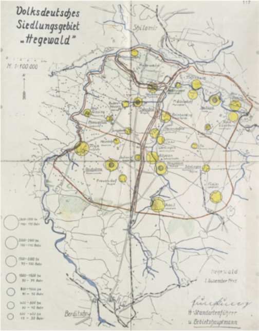
Figure 1. Generalplan Ost (Map of the “Ethnic German Settlement ‘Hegewald’”, dated 1st November 1942, BArch R69/215, Image 0235, Bundesarchiv Berlin).
Whether this practice corresponded to Himmler’s vision of an agrarian paradise in the East is questionable. Although the ethnic Germans enjoyed some advantages over the Ukrainian population, and kindergartens, schools, and nursing stations were founded for them by welfare activists from the Reich (Lower, 2002, p. 235), the settlement project “Hegewald” can be considered a failure. As Wendy Lower puts it, the National Socialist leaders called the ethnic Germans “pioneers of Germandom in the East” and compared them to “frontiersmen who settled the American West”, but, in reality, they had no choice where to settle, as this was decided by “Himmler’s proliferating agencies of race and space planning”; they were “racially selected by the state and placed into an artificial society that had been ethnically ‘cleansed’ by Himmler’s SS-police killing units” (Lower, 2005a, p. 198). Also, the Germans could not protect them from Soviet partisan attacks. From November 1943 onwards, the ethnic Germans were taken by the Sonderstab to the West, namely to camps in Warthegau as the Red Army advanced.
Conclusion
The planning processes for the settlement project “Hegewald” have not yet been documented. The state of research assumes an “ad-hoc settlement practice” in the occupied Soviet territories, which probably took place partially independently of binding settlement and spatial planning (Stiller & Kegler, 2023, p. 403). In this context, the planning processes for the eastern territories between 1941 and 1943 are not regarded as stringent and coherent enough to have borne the National Socialist genocidal practices as a consequence (Stiller & Kegler, 2023, p. 406). On the other hand, Timothy Snyder (Snyder, 2010) and Czeslaw Madajczyk (Madajczyk & Biernacki, 1994) relate the GPO to the “final solution” (Endlösung). Czeslaw Madajczyk sees the resettlement projects in south-western Lithuania, in the Zhytomyr region in Ukraine, and in the Polish region Zamosc, all centred upon forced displacement, forced labour, racial selection, and genocidal violence, as an implementation of the GPO (Madajczyk & Biernacki, 1994, p. 11). More research needs to be done to identify possible links between the GPO planning drafts made between 1940 and 1943 and the realisation on the ground of National Socialist settlement policy as it was carried out for instance in “Hegewald”. Such connections would also raise the important question as to the responsibility of the planners in the context of genocidal practices in Eastern Europe. Konrad Meyer, head of the planning process for the GPO, was acquitted in the eighth Nuremberg follow-up trial. The core of his defence was that the GPO had never been implemented, as it was purely scientific theory and planning for the post-war period (Leendertz, 2008, p. 185). However, it is recorded that Meyer undertook a two-week inspection tour to the Ukraine in June/ July 1943, starting with the district of Zhytomyr, wherein “Hegewald” was located (Madajczyk & Biernacki, 1994, pp. 277-281). The architect Bernhard Kuiper, construction manager in “Hegewald”, was also acquitted in the denazification proceedings. The main argument of his defence was the technical nature of his activity during the NS rule. He defined himself as a “civil engineering employee without any responsibility and decision-making power, as is generally the case with technicians at any technical authority” (III/1526, 1948, p. 87). Beyond the topos of the responsibility of technocrats in the Third Reich, further research should be carried out on the development of spatial concepts after the war and their influence on present-day architectural and urbanistic discourse and practice.
Conflict of Interests
No potential conflict of interest was reported by the author(s).
Biographical notes on authors
Lavinia Munteanu is an architect, visual artist, and researcher based in Germany. Currently pursuing a PhD in architectural theory at Graz University of Technology, her work explores the evolution of spatial concepts through an interdisciplinary lens. As a member of the Degrowth Journal’s editorial collective, she bridges architecture, art, and activism to reimagine futures beyond growth and capitalism.
Endnotes
This paper has been presented at the SPACE International Conference 2023 on Architectural History and Theory.
References
Bauman, Z. (2005). Moderne und Ambivalenz: Das Ende der Eindeutigkeit. Hamburger Edition. Benz, W. (2008). Der Holocaust (7 ed.). Verlag C.H.BECK Literatur - Sachbuch - Wissenschaft.
Böckler, E. (1941). Die Gestalt der deutschen Stadt im Osten. Raumforschung und Raumordnung, 5 (3–4), 212-221.
Christaller, W. (1940). Die Kultur-und Marktbereiche der zentralen Orte im deutschen Ostraum und die Gliederung der Verwaltung. Raumforschung und Raumordnung, 4 (11-12), 498-503.
Culemann, C. (1941). Die Gestaltung der städtischen Siedlungsmasse. Raumforschung und Raumordnung, 5, 122-134.
Grundzüge des Ostaufbaues. (1942a). Deutsche Ukraine-Zeitung(11. February 1942). Grundzüge des Ostaufbaues. (1942b). Deutsche Ukraine-Zeitung, 11. February 1942.
Hagen, J. (2016). Social Engineering, National Demography, and Political Economy in Nazi Germany: Gottfried Feder and His New Town Concept. In Hitler’s Geographies: The Spatialities of the Third Reich (pp. 218).
Hagen, J., & Ostergren, R. C. (2020). Building Nazi Germany: Place, space, architecture, and ideology. Rowman Littlefield.
Heinemann, I. (2003). Rasse, Siedlung, deutsches Blut. Das Rasse-und Siedlungshauptamt der SS und die rassenpolitische Neuordnung Europas. In: Wallstein.
III/1526, B. Z. (1948). Lebenslauf Bernhard Kuiper [archive document]. BArch, Bundesarchiv Koblenz, Spruchgericht Bergerdorf.
Kennedy, H. (2019). Infrastructures of “legitimate violence”: The Prussian Settlement Commission, internal colonization, and the migrant remainder. Grey Room(76), 58-97.
Kuchenbuch, D. (2010). Geordnete Gemeinschaft: Architekten als Sozialingenieure - Deutschland und Schweden im 20. Jahrhundert. transcript Verlag.
Leendertz, A. (2008). Ordnung schaffen deutsche Raumplanung im 20. Jahrhundert. In Beiträge zur Geschichte des 20. Jahrhunderts H1 - Universitätsbibliothek H2 - 48 A 10082:1 (Vol. 7, pp. 459). Göttingen: Wallstein-Verl.
Lévinas, E. (1934). Quelques réflexions sur la philosophie de l’hitlérisme. Esprit (1932-1939), 3(26), 199-208.
Lower, W. (2002). A New Ordering of Space and Race: Nazi Colonial Dreams in Zhytomyr, Ukraine, 1941-1944. German Studies Review, 25(2), 227-254. https://doi.org/10.2307/1432991
Lower, W. (2005a). Hitler’s “Garden of Eden” in Ukraine: Nazi Colonialism, Volksdeutsche, and the Holocaust, 1941–1944. In J. P. J. K. Roth (Ed.), Gray Zones. Ambiguity and Compromise in the Holocaust and its Aftermath (pp. 185-204). Berghahn Books New York.
Lower, W. (2005b). Nazi Empire-building and the Holocaust in Ukraine. The University of North Carolina Press.
Madajczyk, C., & Biernacki, S. (1994). Vom Generalplan Ost zum Generalsiedlungsplan. In Einzelveröffentlichungen der Historischen Kommission zu Berlin / Historische Kommission zu Berlin H1 - Universitätsbibliothek H2 - 35 A 5929 (Vol. 80, pp. 576). München [u.a.]: Saur.
Osayimwese, I. (2017). Colonialism and Modern Architecture in Germany. University of Pittsburgh Press.
Pelt, R. J. v., & Dwork, D. (1998). Auschwitz: von 1270 bis heute. Pendo-Verlag.
Planen und Bauen im Nationalsozialismus : Voraussetzungen, Institutionen, Wirkungen. - 1. (2023). (W. Benz, T. Harlander, E. Pahl-Weber, W. Pyta, A. v. Saldern, W. Schäche, R. Stephan, & I. W. Unabhängige Historikerkommission Bauen und Planen im Nationalsozialismus. Voraussetzungen, Trans.) [Aufsatzsammlung]. Hirmer.
Pohl, D. Schauplatz Ukraine: Der Massenmord an den Juden im Militärverwaltungsgebiet und im Reichskommissariat 1941–1944. Ausbeutung, Vernichtung, Öffentlichkeit: Neue Studien zur nationalsozialistischen Lagerpolitik.
R58/215, B. (1941a). Ereignismeldung UdSSR Nr. 31, 23. Juli 1941 [archive document]. BArch, Bundesarchiv.
R58/215, B. (1941b). Ereignismeldung UdSSR Nr. 33, 25. Juli 1941 [archive document]. BArch, Bundesarchiv.
Rössler, M. (1993). Der “Generalplan Ost” Hauptlinien der nationalsozialistischen Planungs- und Vernichtungspolitik. In Schriften der Hamburger Stiftung für Sozialgeschichte des 20. Jahrhunderts H1 - Universitätsbibliothek H2 - 34 A 322 (pp. 378). Berlin: Akad.-Verl.
Schmitt, C. (1940). Der neue Raumbegriff in der Rechtswissenschaft. Raumforschung und
Raumordnung, 4(1-2), 440-442.
Seidler, F. W., & Zeigert, D. (2000). Die Führerhauptquartiere. F.A. Herbig.
Snyder, T. (2010). Bloodlands: Europe between Hitler and Stalin. Basic Books (AZ).
Steinweis, A. E. (1999). Eastern Europe and the Notion of the ‘Frontier’in Germany to 1945. Yearbook of European Studies, 13, 56-69.
Stiller, A., & Kegler, K. R. (2023). Raumplanung und Gewalt:‚eingegliederte Ostgebiete‘, Generalgouvernement, besetzte sowjetische Gebiete. In W. Benz, T. Harlander, E. Pahl-Weber, W. Pyta, A. v. Saldern, W. Schäche, & R. Stephan (Eds.), Planen und Bauen im Nationalsozialismus: Voraussetzungen, Institutionen, Wirkungen (Vol. 1, pp. 324-429). Hirmer.
Wortmann, W. (1941). Der Gedanke der Stadtlandschaft. Raumforschung und Raumordnung, 5(1), 15-17.